


Cycling Tour :: Ventoux“Wow” Tour [3 days]
- 1 rest day, 1 riding day, 1 rest day.
- 142 km
- 2900 m+
- highest point: 1912 m, Mont Ventoux Summit
- lowest point: 27 m, Avignon.

About the GoogleEarth KMZ files
I have gathered valuable information for you on GoogleEarth for your tour: route, profile, food/drink stations, second start points . . .
![]() Download the GoogleEarth 1-day Ventoux tour detailed route.
Download the GoogleEarth 1-day Ventoux tour detailed route.
Please be aware that this material is copyrighted fabien-haddadi.info . Do not copy for commercial reuse without my authorisation..
Notes
Ventoux Tour is a nice, sunny, and perfumed stop in Provence, that allies a unique ride that is considered the Mecca of climbs by cyclists the world over. It suits people transiting from Paris to the Southern coast and vice-versa, with just a little time to visit Provence, yet searching for a life-long memorable ride in the hinterland. It is a long ride, comparable to Pro-tour stages, with an important positive ascent (nearly 3000 m). It should take you between 5 to 7 hours to complete; in other words, a good working day . . .
Click on the GoogleMaps landmark on the left for more detail.
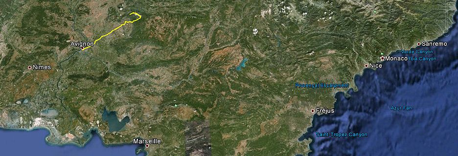
Day 1: Welcome to Avignon, the City of Popes
Welcoming you at the Avignon-TGV station or the Avignon Centre railway station. Check-in at IBIS hotel Boulevard St Roch, a centrally located, safe and friendly hotel. You will spend two nights there. It features a dining room and all-you-can-eat-breakfast. Reminder: 2 dinners and 2 brekkies are included in this tour.
If you have never been to Avignon before, you will be amazed at the ancient stone wall built right around the city. Inside the walls, Avignon has retained its medieval style, is bustling throughout the warm season, and you are guaranteed to never forget this unique setting.
Dinner at Verso, inside the old city. This locally owned Italian-style French restaurant is one of Avignon’s best-kept secrets. Concealed in a little paved square away from the tourists, with friendly staff, baking pizzas in a massive woodfire oven right before you. You will likely welcome their pasta dishes as well on this eve of your Ventoux stage.
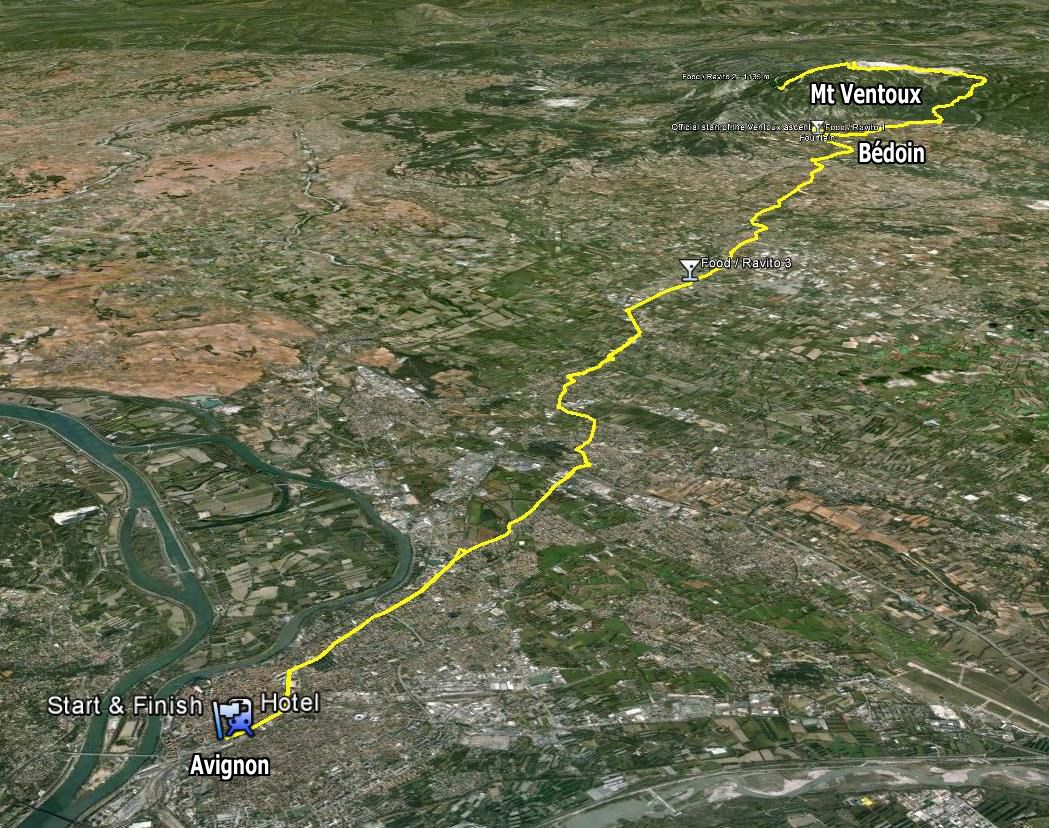
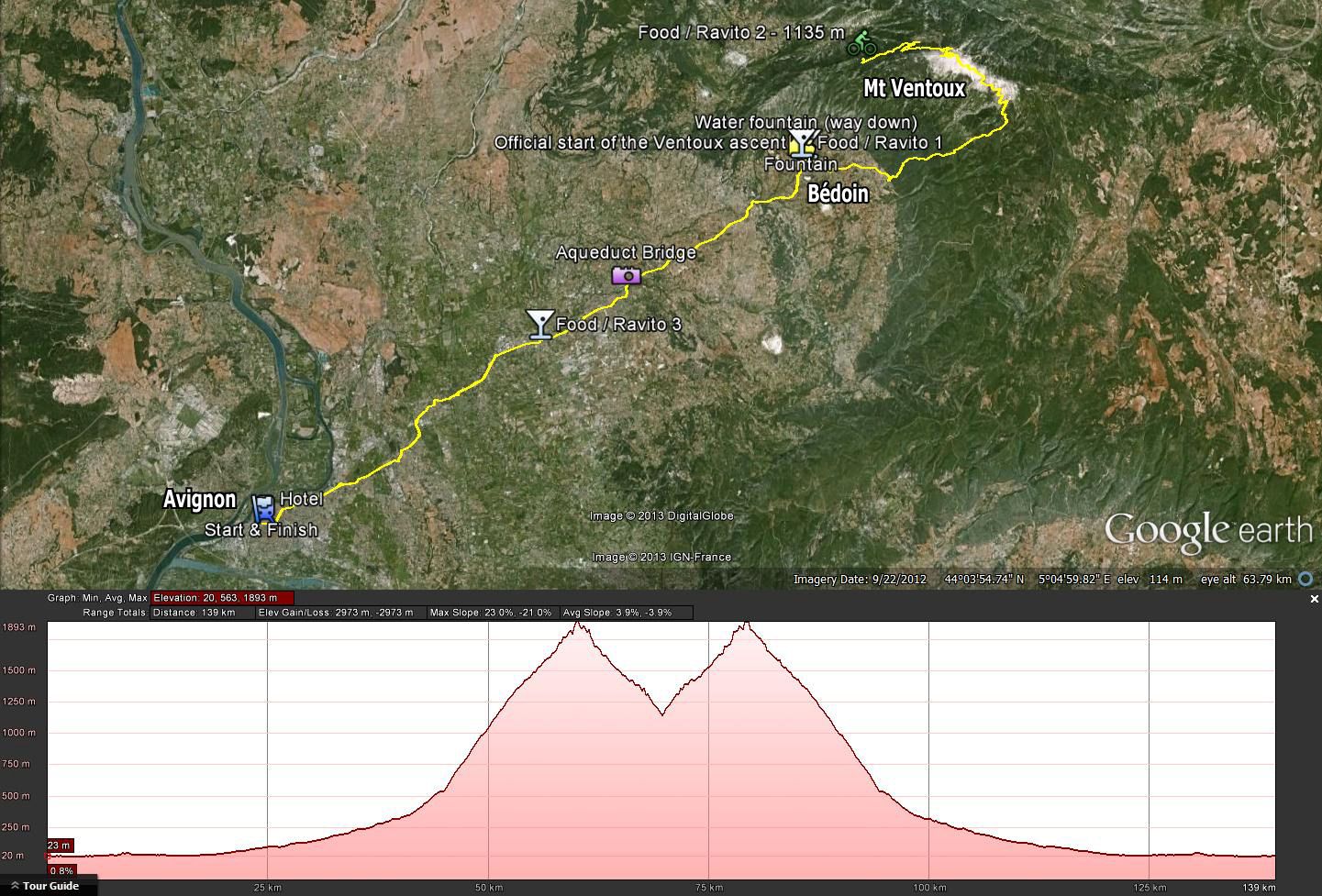
Day 2: The Ventoux Wow Stage, 142 km
start & end alt. 27 m; pos. elevation: 2900 m+; max alt. 1912 m (km 75).
Cities crossed during this stage: Avignon, Carpentras, Monteux, Bédoin.
An anticipated return point, located at Mont Ventoux, 60 km, is available on this stage for cyclists who do not wish to complete the full length. It will still be a 120 km tour length.
After exiting Avignon at Le Pontet you will cross various little villages and bigger towns (e.g. Carpentras), all well separated one from another by vast land, vineyards and forests. Your goal for now is to slowly warm up and get to Bédoin (~320 m), a village located at the foot of Le Ventoux, in as straght a line as possible, to make the journey a little shorter.
We typically see the vast majority of cyclists commence the Ventoux ascent from Bédoin itself, which we think is the one of the worst practices for this type of climb. Commencing at Bédoin would mean your muscles are cold, your muscular cells will not be working in aerobic mode, and since the climb will start right from the outset at the exit of Bédoin, you would start your climb anaerobicly with a feeling of asphyxiation after 2 or 3 km which is when the slope rises dramatically.
At this bend there is a water fountain that should be available when you pass. But don’t waste time here as the stopwatch is ticking over . . . Also, I personally find the next 4 km from that bend are easier, because you are finally out of the woods, up in the fresh air, scarce in O2 you may say, with a white stone lunar landscape surrounding you. Looking at that TV antenna at the top, 500 m higher up, pulls you up the slope.
But before you get there, the 12 km of woods will tire you, I promise. The ever-continuing slope with no respite, with sometimes long endless straight stretches, will wear out your patience as well as your limbs. Stay cold-blooded and don’t burn your thighs before you exit the woods though! After each tight corner you will beg to see a flat to have a little bit of a rest, but the road will cruelly remain steep. I remember doing a climb in 35°C at 1000 m, looking at the altimeter, the only valid source of relief was to finally reach 1400 m in hope of seeing the restaurant flat.
It seems like the road-builders couldn’t wait to finish the last 100 m to the top, so they cut it short and made an impressive hairpin bend at about 24% towards to end!
Our stage manager will be waiting for you at the top to provide you with energy food or whatever else you like, but don’t pause too long, as it is always very windy and you should either continue down onto the other side, the Northern face, or take a quick peek at the viewpoint and return down to Bédoin.
The reason why this spot is windy is because on top of being a mountain top, it is in the middle of a natural 800 km corridor bringing wind straight down from Germany, or up from the Mediterranean sea. It is as if you were in a enormous draft between a cold place and a warmer place on the Earth.
Descend down to 1100 m altitude or so, low enough to experience enough of the Northern climb on your way back up. Half way up, just stop at that Chalet to reful your bottle or get some Orangina, the famous french slightly fizzy drink, with no preservatives or colouring, ready to eat another nearly 800 m of positive climb back to the top. This climb is known to be“easier”. You should find it easier as you are now in the heat of the action, fully prepared for this ascent after the Herculean climb you just achieved. However, depending on your physical condition, this is also now that a cramp could strike. So take it easy.
On your second pass at the top, you should experience a feeling of great accomplishment for the day. You may even feel that indestructible, except maybe for the lack of minerals or sugar in your bloodstream! Here again you can and should grab more food, to be eaten as the opportunity arises during your descent. The idea is that, like the pros, you use the descent time to stretch and replenish your biological stores. Keep in mind that when you are back in Bédoin, another 40 km will be waiting for you ahead. This time the fake flat will be playing in your favour.
What’s the (Southern) descent like?
Fast and safe, or so I feel. I find that the natural wide-angle, long-distance visibility, and good light in the descent allow you to travel safely at a speed of 70 km/h with no particular danger. Make sure you watch for motorbikes and cars long before you get to a corner, so that you are 100% sure there will be no surprises once in the corner. Occasional long, straight lines allow stretching and eating.
Don’t stay too long behind cars, they will advance slower than you and brake a lot harder than you.
About 1 km before Bédoin is a carpark and a fountain on the left. Once again you will have an opportunity to stop for a bottle refill.
40 km of road follows from this point down to Avignon through Monteux. For those who are starving to death, indulge yourself or replenish your stocks at the Boulangerie mentioned on the GoogleEarth route that you can ![]() download here. They are open until late, including on Sunday nights and public holidays, and the scenic road to Avignon is still long.
download here. They are open until late, including on Sunday nights and public holidays, and the scenic road to Avignon is still long.
Stage finish at Ibis Gare Avignon Centre. A good shower and a nice dinner will be waiting for you. If you can’t be bothered walking back to the city, you can have your meal at the dine-in restaurant of Ibis which is included in your tour.
Day 3: Freetime in Avignon
All-you-can-eat brekky, well-earned after yesterdays hard yakka. Checkout at 12pm, with free use of the secure locker room behind the counter. That should leave you with ample time and no suitcase or bike to roll to give the city a good visit.
Sightseeing suggestions
- The St Bénézet bridge, aka Le Pont d’Avignon, a bridge built in the XII-th century and destroyed repeatedly by floods of the river Rhône. It used to be the main method of crossing the river Rhône to travel to Lyon, formerly the capital of France under Roman occupation, and has remained a large commercial marketplace ever since.
- Le Palais des Papes. The actual palace where Popes were elected and resided for some time before returning to The Vatican later in history.
Need a TGV to go from A to B?
Avignon is a convenient and efficient train hub where two major lines, North-South and West-East cross. Many southbound TGVs from Paris to Marseille, or Nantes to Marseille, would stop in Avignon, as well as TGVs going to Eastern France or Switzerland.