


Cycling Tour :: Sunseeker Express [6 days]
- 6 days in 5 riding days + 1 rest day
- 610 km
- 11,800 m+
- highest point: 1924 m, Col du Glandon
- lowest point: 10 m, Promenade des Anglais, Nice.

About the Google Earth KMZ files
I have gathered valuable information for you on GoogleEarth for your tour: route, profile, food/drink stations, second start points . . .
![]() Download the GoogleEarth Sunseeker Express detailed route.
Download the GoogleEarth Sunseeker Express detailed route.
Please be aware that this material is copyrighted fabien-haddadi.info . Do not copy for commercial reuse without my authorisation.
Notes
Sunseeker Express will take you across a couple of parallels South to finally reach the“Big Blue” as French call it. You will have a chance to appreciate the change in climate, vegetation, housing style, roof colour and sky colour as days go by.
Sunseeker starts in a town located East of Lyon, but not in Lyon itself. There are many reasons for this:
- It saves you from riding through the third largest city of France, hence avoid excessive red light stops, heavy traffic, and fumes.
- Starting from Lyon would make this first stage nearly 180 km.
- Lyon to Bourgoin is a bit boring, it consists of vast plains with no major ascent profiles.
- It’s easy and cost effective to get to Bourgoin from Lyon by train.
- *There is a historic dimension in starting from Bourgoin and riding to Nice, see the info block below.
Sunseeker Express travels along portions of it. No doubt you will notice restaurants or hotels named "Napoléon" along the way. You may feel a sense of achievement completing this portion of road which only Great Men come to experience . . .
Day 1: Bourgoin-Jallieu (Lyon) to Sainte-Marie-de-Cuines, 134 km
start alt. 256 m; end alt. 455 m; pos. elevation: 1300 m+; max alt. 650 m (km 57); min alt. 239 m .
Départements (provinces) crossed during this stage: Isère (38), capital: Grenoble; Savoie (73), capital: Chambéry.
Notes: This is the longest stage of this tour.
A second start point, located at 49.5 km, is available on this stage for cyclists who do not wish to complete the full length.

Click on the GoogleMaps landmark on the left for more detail.
I suggest you start at around 11:30am, so that we start off when the French are off on their lunch breaks. This means a big drop in traffic for a couple of hours, literally.
For those of you who will ride for the first time in France, don’t be nervous, this is what to expect from riding in France.
Since we are heading East and gently ascending as we go, soon after leaving Bourgoin you will see a panorama of the Alps in the distance. Just think that a few hours from this point you will actually commence traversing them. The crossing will take another 4 riding days.
You will gradually be leaving the large plains of La Vallée du Rhône, named after the 812 km major river that flows south to the Mediterranean Sea near Marseille, and commence a climb up a long ramp to the North-West door to the Alps, following a path down the“Chook” neck. Ask Fabien what the“Chook” is . . .
You are well on your way to the sun! In the meantime, a little cultural trivia . . . cars that pass by you will surely have kids in them playing a popular educational game with their parents while they drive: to call out the Département names from the two-digit number on licence plates that they pass. It’s a bit like an educational "I-spy"
In“Cuines”, as locals call it, as luck would have it, a new Intermarché supermarket has just been built in 2012, just opposite the hotel. Here we can find really good ready made meals and a huge array of snacks and fresh foods. You really should check out the product variety. There is also a buffet / restaurant just opposite that is open till late with generous servings.
Day 2: Sainte-Marie-de-Cuines to Grenoble, 133 km
start alt. 455 m; end alt. 222 m; pos. elevation: 3500 m+; max alt. 1924 m, (Col du Glandon, km 21); min alt. 222 m .
Départements (provinces) crossed during this stage: Savoie (73), Isère (38).
Note: This is hardest stage as it features two "Hors-Catégorie" (Uncategorised) passes: Col du Glandon followed by His most respected Highness L’Alpe d’Huez.
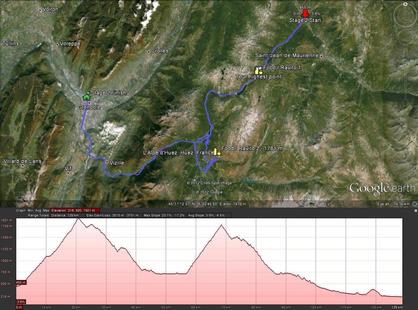
After Le Col du Glandon, where you just had a snack and grabbed some more food in your jersey pockets, the hardest part has not come yet . . . It will after Allemont, with the turn off to the left, and the straight line leading to the 21 numbered bends of infamous Alpe d’Huez, a Tour de France must-climb. Until then, part of the route is a long descent, with a few steep ascents at times. Please observe the greatest care when descending from Le Col du Glandon to Allemond, as there are some long straight portions followed by hairpin bends or blind corners. Be careful at all times, especially in wet conditions. However, you’ll be happy to know that the road surface is quite grippy and I myself have flown down these roads in heavy rain with no grip problems whatsoever. I do encourage caution, and can’t stress this enough.
Please note that despite road D1091 being a busy road, a large portion of it has a bike lane. This is no great surprise when you know that this is the only road used by cyclists who come from the big city nearby - Grenoble - who like you are also on their way to the famous 21-bend ascent.
Despite being the shorter stage of this tour, it is nonetheless physically demanding in the first 21 km. The rest of the stage is mostly a long descent into the modern and academic city of Grenoble, which is known for the preservation of its Old Town, with little streets, quaint cafés, and restaurants.
The amazing feature of Grenoble is the fact that it is surrounded by mountains.
You may hear other Australian accents at the hotel here as Grenoble is a good base for Alps cycling, in particular l’Alpe d’Huez, which is climbed in le Tour de France almost every year.
Day 3: Grenoble - Gap, 104 km
start alt. 222 m; end alt. 738 m; pos. elevation: 2200 m+; max alt. 1256 m (Col Bayard, km 95); min alt. 222 m .
Départements (provinces) crossed during this stage: Isère (38), Hautes-Alpes (05), capital: Gap.
Note: an earlier finish point, located at km 69.5 is available on this stage. It allows the most scenic part of the stage to be ridden.

The first kilometres are ridden on the same road that the previous stage ended on: the long straight line through Echirolles.
The first half of this stage is very scenic, with two long turquoise lakes on your right as you slowly ascend up to nearly 1000 m - you can’t miss them, they are magnificent and you will surely remember them in years to come! I encourage you to stop and take a pic here, it really is worth it. The sun can beat down quite hard on this slope, and it’s not uncommon to experience temperatures over 35°C even at over 900 m altitude. Luckily there is a mountain water fountain at the top of the first climb that delivers a slow yet permanent stream of really cool, refreshing water. Drink up and refill here!
You might find the climb to the last and highest pass of the day too long, although it is in fact rather short. It will take you as high as 1200 m, rewarding you with a scenic winding yet fast descent in to Gap.
Day 4: Rest day in Gap
Gap is the capital city of Les Hautes-Alpes, an active city known both for summer and winter sports. It is also a passage for cyclists on their way to Embrun, place of France’s longest triathlon (Embrun Man).
Gap has allied History and Modernity, keeping the warm atmosphere of its Old Town as well as looking forward to modern infrastructure, such as the unequalled Alp’Arena, a state-of-the-art Ice Stadium for all ice sports.
This active town will no doubt charm you, and great news . . . we arrive on a Saturday and have Sunday off!
Day 5: Gap - Senez, 133 km
start alt. 738 m; end alt. 820 m; pos. elevation: 2980 m+; max alt. 1358 m (Col de Maure, km 62); min alt. 600 m .
Départements (provinces) crossed during this stage: Hautes-Alpes (05), Alpes-de-Haute-Provence (04), capital: Digne-les-Bains.
This is the biggest stage in positive climb.
Note: a second start point, located at km 62.7 is available on this stage.
Alternative route note:
The strategy here is to head South East to the "Alpes-de-Haute-Provence", a département that is the gateway between the Hautes-Alpes and Alpes-Maritimes (our destination). But, yes there is a but, a mountain is located South East of Gap . . . There are two ways to go around: West or East.
I have chosen to go around East, despite it being the longer option, because the views of Lac de Serre-Ponçon are just incredible at this time of year. The waters wear a breathtaking blue coat that you will remember all your life, just that. Also, the descent onto the dam is just amazing. Stop and take pics, this isn’t a time trial afterall!
Whatever route we take, the aim is to get to Espinasses / Rousset, and cross the bridge to cross the South-West tip of the lake, near the dam.
You are now leaving the Rhône-Alpes Region and are entering the PACA Region (Provence-Alpes-Côte d’Azur) as you cross this bridge. A picturesque gorge in front of you acts as a gateway to this next region. From this time on you will be climbing up to the highest point of this fourth stage, up to 1358 m high. The weather can be really hot and dry on this road.
After a long descent onto Digne, you will head South to Col de Corobin, 1228 m, through a remarkable avenue: Avenue des Thermes. Thermes, as you can guess, are natural hot spring baths. A lot of tourists stop here for a few days to relax. It isn’t unwind time for you though, as you have another Col to wind up for!
After this magnificent climb, you will fly down to Barrême (watch for hairpin bends, and sometimes deer on the road if you ride towards the end of the day. You will then rejoin Route Napoléon (N85) that will gently lead you to your guest house for the night in Senez, about 15 km before the city of Castellane, which is famous for being the door to Gorge du Verdon.
At this place, the N85 is very calm and Senez is a quiet place anyway. You should now have a really good nights sleep, and a well-deserved transition to your last stage tomorrow.
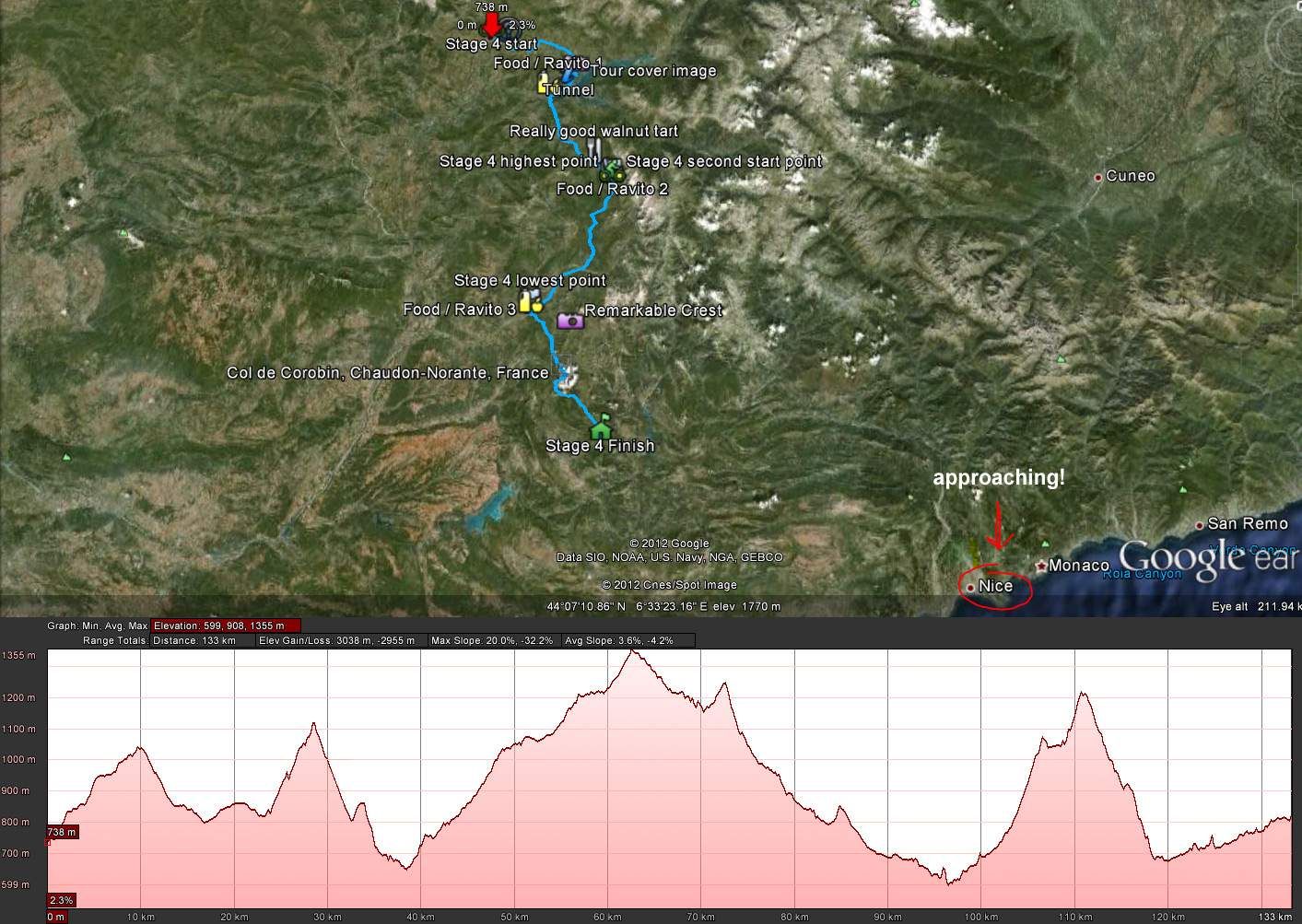
Day 6: Senez - Nice, 102 km
start alt. 819 m; end alt. 10 m; pos. elevation: 1900 m+; max alt. 1183 m (km 50); min alt. 10 m .
Départements (provinces) crossed during this stage: Alpes-de-Haute-Provence (04), Alpes-Maritimes (06), capital: Nice.
This could be the hottest stage, as we are crossing the French bush (arrière-pays).
Note: a second start point, located at km 35.5 is available on this stage.

Today is the big day, we reach the Mediterranean Sea in Cagnes-sur-Mer and follow the coast up to La Promenade des Anglais in Nice. But before this, let’s suffer one last time . . .
As you leave the guest house, you haven’t yet ridden 500 m and you have already started a hard yet scenic climb up to 1150 m under a sun that has never been as hot since you left.
After this first early pass, there is a fast, winding, and sometimes windy descent onto picturesque Castellane, the gateway to Les Gorges du Verdon (one of the most popular holiday places for French and . . . the Dutch! Just some interesting trivia . . . .take note that just about every second car has an NL plate! I guess it means this region is magnificent, and you are just about to discover why.
There are three more passes until you reach Nice. The last is particularly nice, as you climb up along a sharp 1500-metre high crest on your left that will follow you until you reach the summit.
Finally, the descent onto the coast is announcing what you have been waiting to see: the sea. You are leaving the dryness of the bush to enter a cooler but more humid climate. Along“Les Gorges du Loup” (literally the“Wolf Throats” in French), except Le Loup here is a river, that welcomes you and leads you to Cagnes-sur-Mer, your first encounter with the Mediterranean Sea on this tour. Welcome to La Côte d’Azur, welcome to Nice, and Well Done!
You have done a really great job. Well over 10,000 m of positive climb over nearly 600 km. You absolutely deserve a good relaxing time at the beach.