


5 cycling routes in Adelaide, South Australia
Download the corresponding GoogleEarth data for each route at the end of each section.
May I suggest that GPS never lead you to the point you lose your sense of orientation.
It took 50 000 years of evolution of mankind to make us intelligent and be able to orientate ourselves in nature, following common sense, sun, and natural features.
Promise me to make an effort to mentally visualise your route in three dimensions before you go for your ride, before pulling out that smartphone at the first unsigned crossroads.
1/ The 45 km“Hillside Riding” (710 m, 2329 ft)  Medium difficulty

This climb is ok to be ridden day as night as there’s enough lighting to do it safely in the first 8 km of the climb. The last 4.5 km are pitch black on moonless nights though. Watch for koalas or kangaroos in the middle of the road as you’ll fly down at 70 km/h. I often see some. A good front light will make it safer on the dark leg starting at Grand Mercure Lofty.
In winter, the East side of the hills can get quite cold, normally 6-8C at sunset. For that reason, you may like to stay on the west side, and repeat that Lofty climb from Toll House to the restaurant. Three times will assure of a good training.
![]() Download this route #1 on GoogleEarth.
Download this route #1 on GoogleEarth.
![]() Download all of my Adelaide routes on GoogleEarth.
Download all of my Adelaide routes on GoogleEarth.
2/ The 64 km“Beachside Riding”  Easy
Easy

No particular difficulties on this route, except maybe the head wind as you return southwards. There’s a dominant southerly almost all year round in Adelaide. It can make this route tougher than you think, specially if you keep your speed above 30 km/h southwards.
![]() Download this route #2 on GoogleEarth.
Download this route #2 on GoogleEarth.
![]() Download all of my Adelaide routes on GoogleEarth.
Download all of my Adelaide routes on GoogleEarth.
My personal best on this route: 2:00
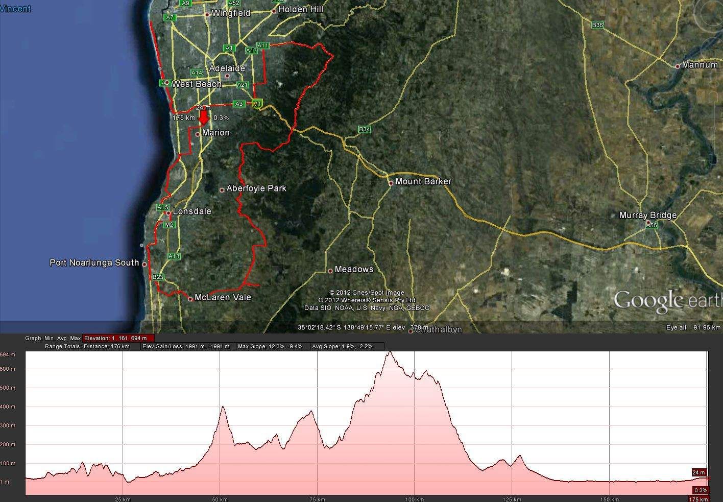
3/ The 105 km“La route des vignobles” (Vineyard Riding) Medium difficulty

Nice diversity of sceneries on this route, that I get never get bored of. First Hallett cove and its 180° panorama on St Vincent gulf. Then Port Noarlunga. Then this interesting pine forest section on the track before Mc Laren Vale, followed by Mc Laren itself and its vineyards on both sides of the road. Finally the Kuitpo climb and its cows will remind you of the French Alps. You’ll see the gulf and Mt Lofty in the distance on clear days.
![]() Download this route #3 on GoogleEarth.
Download this route #3 on GoogleEarth.
![]() Download all of my Adelaide routes on GoogleEarth.
Download all of my Adelaide routes on GoogleEarth.
4/ The 115 km "Tour des Cols+" (Passes Tour+), 2185m+  Hard
Hard

![]() Download this route #4 on GoogleEarth.
Download this route #4 on GoogleEarth.
![]() Download all of my Adelaide routes on GoogleEarth.
Download all of my Adelaide routes on GoogleEarth.
My personal best on this route: 4:29
A slight variant of this route is: instead of going up and down Torrens Hill Rd, stay on Gorge Rd. It’s still 113.9 km.
If like me you prefer to ride in the second half of the afternoon, to avoid too much UV exposition, note that the temperature on the other side of the Lofty Ranges is usually equivalent to the low forecast of the next morning at sea level. In short, it’s usually 10 degrees Celsius less than in Adelaide City towards the end of the day. I advise you to take advantage of the Mount Lofty bottle filling stop to wear a windproof jacket and maybe overshoes. It’s quite unconfortable to start to wear your overshoes as you climb Lofty, as the température is usually warm, even in Winter, on the West side of the hills during your ascension.
Climax of this tour:
5/ The 180 km“Dahu tour”, 2074m+ Medium difficulty
Start: anywhere on the loop.
![]() Download this route #5 on GoogleEarth.
Download this route #5 on GoogleEarth.
![]() Download all of my Adelaide routes on GoogleEarth.
Download all of my Adelaide routes on GoogleEarth.
My personal best on this route: 6:36:15
The specialists will recognise here that this distance is equivalent to the bike leg of an Ironman. It will be obvious to the best eyed of them that a full Ironman is here made possible in Adelaide.
Find Fabien’s best times on these routes here.
Finally I could not close without citing some memories: The fastest descent, in my view, in the Adelaide region, is that leading down from Delamere at Rapid Bay, with an Easterly wind (90.0 km/h on my SEIKO quartz speedo). The most extraordinary encounter I’ve had with the wildlife is the meeting with an oncoming kangaroo around a blind corner (Mount Lofty). And also, having seen 3 long snakes flee into the grass alongside the bike path leading to McLaren Vale (spring time). The coolest all-terrain bike trail (in my experience) is the Mawson Trail from Wilpena Pound till Bunyeroo Gorge.