


How do you calculate the height of the Sun at time t? A journey into the land of unknown light . . .
In this article, I’ll prove that this phenomenon exists, and work out the exact dates when it happens. Welcome to the land of unknown light.

Disclaimer
This educational article is aimed at readers familiar with some notions of geometry, especially trigonometry (sine, cosine and tangent), and basic notions of geography, in particular the definitions of latitude, the tropics and the ecliptic. If, despite my reminder below, these notions still leave you wide-eyed, I invite you to look these terms up on your favourite reference site, then come back to carry on reading this article, which will seem much clearer that way.
Notation
The real number pi will be written π from here on.
Angles will be expressed or understood in degrees, since we’re working in geography, rather than in radians as is traditionally the case in trigonometry.
Reminders
Geometry
- polar coordinates: a two-variable coordinate system of the plane: the radius r and the angle θ, describing the position of a point in problems with circular or elliptical symmetry. The point is at distance r from a centre of rotation, or from a focus in the case of an ellipse. In this article, the angle θ will take values between 0 and 360°.
- generatrix of a cone: a straight line which, rotating around an axis (other than itself), generates a cone. To put it simply, imagine you grab a stick by one end and twirl it with your wrist without moving your arm. The stick is the generatrix of a cone, since by turning around the axis of your forearm it virtually draws a cone in the air.
Trigonometry
- cosine: in a right-angled triangle, the ratio adjacent side / hypotenuse. It ranges over the interval [-1, 1]
- sine: the ratio opposite side / hypotenuse. Opposite in the sense of “opposite the angle considered”. It also ranges over [-1, 1], and is zero when the cosine is at its peak, and vice versa.
- tangent: the ratio sine / cosine. It ranges over [-∞, +∞]
- arctangent: the inverse function of tangent, i.e. the angle whose tangent equals the value considered.
e.g. arctan(1) = 45°, since tan(45°) = 1.
Geography
- latitude: an angle, expressed in degrees, defining your north-south position. It can range from -90° (south pole) to 90° (north pole), going through zero at the equator.
- tropics: the limits on Earth that the sun’s zenith (the spot where the sun is seen straight above an observer) will never go beyond. In other words, the overhead sun oscillates between the northern (Cancer) and southern (Capricorn) tropics. North of Cancer, the sun will never pass directly overhead, and the same goes south of Capricorn.
The tropics currentlyR1 sit at a latitude of 23°26’15" north (Cancer) and 23°26’15" south (Capricorn). - ecliptic: the apparent path of the Earth along its orbit around the sun. The Earth is currently R1 tilted on its ecliptic by ε=23°26’, so that the Sun sees it from a different angle every day (see the hands-on experiment below).
Hands-on activity
I’d like you to get a real feel for the impact of the Earth’s tilt on the seasons. It’s the tilt that creates the succession of the seasons, and their return every year (more or less gloriously, but that’s another matter).
To experience for yourself the practical consequence of the globe’s tilt on the ecliptic, head to a shop selling globes, Nature et Découvertes in France for example, with no particular deal with them . . . Go with a friend.
Stand on either side of a globe sitting on the shelf, and compare how much of the poles each of you can see. Now do you understand why, as it turns around the sun, the sun sees a little more or a little less of the polar caps every day?
Interpretation:
As you can see in the diagram below, depending on where you stand relative to the globe, and by lifting it to around eye level, you may see the whole Antarctic cap, or the Arctic one, or exactly half. In the diagram, the sun’s light is shown by the big yellow arrows. Your eyes looking at the globe are a bit like the sun looking at the Earth. Well, believe it or not, the sun is subject to the same views depending on the day of the year. We’ll see it below.

Right, back to our original problem: perceived brightness. We all agree that under the same clear sky, light seems much stronger in summer than in winter. This simply comes from the angle of incidence of the light relative to the horizontal, say the ground.
Indeed, a ray of light from the sun will go through all the more absorbing matter (the various layers of air and gases in general making up the atmosphere) the lower it comes in. As Mr Rebufié, my Year 12 biology teacher, used to say, "it’s the principle of the salami slice cut at an angle or straight: its width depends on the cutting angle".
So here’s our first law:
Under the same clear sky, the perceived brightness is all the greater the higher the sun is in the sky.
Conversely, it is all the more subdued the lower the sun is relative to the horizon.
From this point on, and for the rest of the article, I’ll assume the observer (you!) has a clear sky overhead. An overcast sky is too complex to handle, as it can’t be quantified.
Quantifying perceived brightness
Now I’ll try to define a quantity able to describe perceived brightness. In my demonstration, working with quantities is necessary to break free from subjectivity.
Quantifying a feeling is always tricky, since it’s qualitative by nature. But I’ll lay my cards on the table: I choose the culmination point, i.e. the sun’s maximum height on the day considered. From now on, I’ll call the culmination date the day and exact time of the culmination point.
To simplify my analysis, I assume that the feeling that will stick in my observer’s memory for that day is the brightness they observed around the time of the culmination point, i.e. when the sun is highest in the sky that day.
Right, have I lost anyone? If the paragraph above isn’t clear, take your time to reread it, because now comes the more technical part; but I’ll do my best to stay purely geometric and simple as long as possible, so as not to lose anyone on the way. If later on you don’t follow a proof, it doesn’t matter: just accept the theorem (law) that follows, and keep reading.
Well, after all that, we can distil our second law straight away, still assuming a clear sky, but that assumption was made earlier, as a reminder. On a given day, the perceived brightness at a place is proportional1 to the height of the culmination point.
Ok, all this may seem a bit trivial so far, but as always in science, you have to move forward one proven law at a time, little by little, make the approximations that are called for, and take plausible working assumptions.
So you want the hardcore stuff? We’ll try to keep it to a minimum, but there will be some, I promise.
I’ll try to do without equations as long as possible, appealing to common sense as much as I can. Besides, isn’t it the dream of every preparatory class teacher for their students to come back to common sense when they’re tangled up in their equations?
Those culminations new to your eyes . . .
As a reminder, here’s what we’re looking for: culminations new to your eyes. Higher or lower, in fact. We’ll see when we’re in one case or the other.
Law no.3
Let an observer be at P, at latitude λP,
let the sun, at this time of year, pass at its zenith at latitude λS,
then the sun will culminate at noon2 at a height
h = 90°-(λP - λS)
Its proof is given a little further down.
From it we deduce its corollaries C3 and C3’:
If you travel closer to the equator, then at some point in the year the sun may culminate at B higher than you've ever known at your starting point A.
If you travel closer to a pole, then at some point in the year the sun can only culminate at B lower than you've ever known at A at any time of year.
What on earth does that mean? It means that if you live in Norway (A), for example, and travel to New Caledonia (B), you should expect the sun, in summer, to reach heights that exceed any you’ve ever known in Norway. Indeed, you’ve moved closer to the equator, since the latitude of New Caledonia is far lower than that of Norway, setting aside the + or - sign, which by convention means North or South respectively.
Another example: if you live in Brisbane, Australia (A), and travel to Paris (B), in the Parisian winter the sun will culminate at heights lower than any you’ve ever known in Brisbane, whatever the time of year, because Paris is closer to a pole than Brisbane is.
We can see what this means: in the introduction, I said that because of the Earth’s tilt on its ecliptic, the sun passes directly overhead, so as high as possible, over places spread across the intertropical belt. So the closer you get to a pole, the more you say bye-bye to that verticality. Its culmination will therefore get lower and lower as you move closer to a pole.
Vocabulary
Remember low latitudes (meaning in absolute value) as those of places closer to the tropics, and a fortiori to the equator (0°, you can’t get lower!), and high latitudes (meaning in absolute value) as those of places closer to the polar circles, and a fortiori to the poles (90°, you can’t get higher; North or South, we still speak of high latitude).
Proof of law no.3
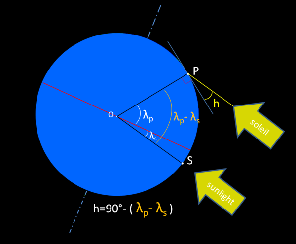
Graphically, we can see clearly where the 90° minus . . . comes from:
if λP = λS, i.e. the observer is exactly under the sun, which therefore passes at its zenith at noon; then for every degree they walk north, for example, the sun is one degree further from the observer’s zenith, because the poor sun hasn’t moved one degree north . . . Which results in a culmination reduced to 89°. For one more degree walked north, the sun will only culminate at 88°, etc. In fact, for Δ degrees further north, the sun will only reach its maximum height at 90-Δ degrees.
We easily deduce that for a latitude difference Δ = λP - λS, counted positively if P is north of S, it is indeed 90° - (λP - λS) that will be the sun’s maximum height at noon.
And it works the same way moving south: if the observer walks one degree south, the sun will pass one degree beyond the vertical, so 90°+1° above the horizon. If the observer keeps moving south, it will pass at 92°, i.e. 2° beyond the vertical, etc. We do have 92°=90°-(-2°), -2° since the observer has this time moved south.
Applying it to a trip towards the equator, to place ourselves within corollary C3, we decrease λP, so we increase the sun’s culmination (since λS is fixed on a given date, and applies globally, independently of the point P considered).
Conversely, on a trip towards a pole, we increase λP to values higher than at A in the northern hemisphere, or so negative in the southern hemisphere that the sun tips well beyond the vertical at noon; so in both cases, the sun’s culmination gets closer to the horizon, the southern or northern horizon depending on the hemisphere.
We deduce a corollary: Anywhere 'north of the sun'3, the sun passes to the south at noon. and its converse Anywhere 'south of the sun'3, the sun passes to the north at noon.
However, note that the sun will produce the same brightness whether it is +n degrees or -n degrees from the vertical. So, to account for latitude being an algebraic quantity, i.e. carrying a + or - sign, we’ll introduce into Law no.3 the absolute value function, which removes the dependency on one hemisphere or the other. Law no.3 can then be written globally as:
h = 90°-( |λP| - λS)where |x| is the absolute value of x. Corollary: in Melbourne, Australia, well south of the tropic of Capricorn, the sun rises in the east, passes to the north at noon, then sets in the west. But in Cairns, also in Australia, a place at almost 17°S, i.e. -17°, so between the equator and the tropic of Capricorn, but fairly close to the tropic, the sun passes to the north at noon most of the year, but has dates when it passes south of Cairns, when the sun's latitude3 λS is lower (= further south) than the city's latitude.
Working out the dates of unknown light
So I’m saying that depending on your position on Earth, you perceive more or less brightness, sometimes in a way unknown to your eyes, brighter or darker than you’re used to. And I’ve just shown that it’s the sun’s maximum height above the horizon that determines brightness. So my original problem boils down to:
- over what interval does the culmination point vary at your former place “A” over the year?
- over what interval does the culmination point vary at your new place “B” over the year?
Ideally, we’d like to plot culmination point graphs for A and B, and solve graphically. By reading the limit abscissas, we’ll be able to deduce the existence of days in the year when the sun is either higher than the max of its known heights at point A, or lower than the min of known heights at point A.
Which amounts to: "the culmination is either to the right of the upper bound of interval A, or to the left of the lower bound of interval A."
Free translation
For those to whom mathematical phrasing brings back bad memories, I’ll translate it as:
We’re going to look for the days of the year when the sun at B is higher than at home in A, or lower than at home.
And I’ll even boil it down to:
- On what dates do you leave the familiar interval A while living at B? (Question 1)
- On what date do you come back into that familiar interval A? (Question 2)
So how do we answer these questions?
To fix ideas, let A be a city at a higher latitude than B. High in the sense defined earlier. The reasoning below obviously works the other way round too.
We’ll use my favourite method, the graphical one. We’ll plot the culmination angle curves over the year for each of points A and B, from one winter solstice to the next year’s winter solstice. Since A and B have different latitudes, the curves will stack up like plates, so to speak. A being further from the equator than B, the sun’s culmination curve at A will naturally sit below B’s curve. In other words, the sun is closer to the horizon at A than at B.
I’m now almost ready to plot the culmination curves for A and B. We deduce from law no.3 that the equations of these curves are of the form:
y = f(x) = 90 - x +λS
With x = the latitude of the point considered, so λA or λB.
Hmm, I was about to plot them when I noticed I was missing λS . . .
Uh oh! We said in the introduction that the sun’s latitude λS oscillates between the two tropics, with a one-year cycle, but I haven’t defined the exact value λS(t), i.e. its instantaneous value on date t.
Never mind, I’ll work out the expression of λS(t) here, in front of you, so we can plug it into law no.3 and get y = f(t) instead of y = f(x). It’s much nicer to have no more unknowns in your equation, only t, a well-known variable since it gives the number of days elapsed since the last winter solstice.
Why? Because it’s at the winter solstice that the sun has its lowest culmination point above the horizon. The winter solstice is therefore a notable point, which will serve as the origin of our graph.
Summary
We’re going to work out graphically the days of the year at B that can never “match” the brightness at A. We do it graphically by drawing y = f(t) at A, and y = f(t) at B. We don’t know f(t), but we’ll look for x(t), then plug it back into law no.3 to get y = f(t).
Those who can’t follow the proof below because it’s too technical, go straight to law no.5, accept it, then keep reading.
Chosen approximations
As always in nature, things aren’t perfect shapes, so to simplify the study we’ll make the following approximations:
- the Earth’s orbit around the sun is considered circular.
- the Earth’s orbital speed is considered constant over the year, so that its polar angle is proportional to the day of the year.
- the Earth is considered spherical, with radius R
- the origin of the Earth’s polar coordinates on its orbit, represented by θ=0, will be arbitrarily set at the boreal winter solstice, i.e. 20, 21 or 22 December depending on the year.
Law no.4
Let θ be the polar angle defined in the reminders at the start of the article, then:
θ(t) = (Q(t) - Qlast boreal winter solstice)/365*360We’ll write Q0 = Qlast boreal winter solstice
Q is the day of the year, i.e. the day’s number since the start of the year.
Example: Q(2 March 2014) = 60; Q0 = 354
We deduce θ(2 March 2014) = (60 - 354) / 365 * 360 = -290° ≡ 70°
Proof of law no.4
It’s simply a corollary of the approximations above:
the polar angle is proportional to the day of the year, since the Earth’s orbital speed is assumed constant. The orbit’s radius is constant. So its angular velocity is constant and equals 360° / 365 days. So every day the Earth travels by a constant polar angle increment of 360/365, which lets us locate it exactly on its circular orbit every day.
Law no.5: λS = f(t)
Right, let’s look for the sun’s latitude3 as a function of the day of the year. Since law no.4 gives us an expression θ = g(t), t being the day of the year, law no.5 will first be established as λS = f’(θ), so as to then reach λS = f’(θ(t)) = f(t)
First, let me appeal to our intuition. What kind of law do we expect? A linear law? A power law? A trigonometric law?
Hmm, at this stage I can’t make up my mind, as I find it hard to define what this famous angle “latitude of the sun” is. So back to the definition: it’s the latitude of a point on Earth where the sun is directly overhead at time t, regardless of its longitude. What do we know about this angle? It’s zero twice a year, at the equinoxes, since the sun is then exactly above the equator as it changes hemisphere. Also, it reaches its minimum and maximum at the solstices. Observant readers will have noticed that around the equinoxes, day length increases or decreases fastest in the year when you live in temperate regions. You can easily gain or lose 3, 4 or even 5 minutes of sunshine a day. Conversely, around the solstices, day length seems frozen, it barely changes from one day to the next. You can check this by looking at a calendar showing day length over the year in your capital. This function is symmetrical about the equator: for any day considered in the northern hemisphere, there’s a date at the opposite end of the calendar, so 6 months later or earlier, when the southern hemisphere experiences the same angle, but with the opposite sign. This is due to the Earth’s spherical symmetry, hence the circular symmetry of a meridian considered at time t. Finally, since the Earth’s orbit is closed, this function is cyclical, with a period of 1 year
In short, a function that is zero twice a year, takes a minimum and a maximum in turn 6 months apart, and is symmetrical about the x-axis . . . could well be trigonometric!
The cone of revolution
Here lies the heart of the reasoning. I’ll use a trick to measure the angle λS. I’ll consider that, seen from the sun, the Earth no longer turns, but instead its axis turns around a line of revolution, making with this axis an angle ε equal to 23°26’. This is what’s commonly called a change of reference frame. This line of revolution lies in the Solar Frontal Plane (SFP), such that at any moment, the sun’s rays arrive perpendicular to this plane. So every point of the SFP sees the sun exactly overhead.
The cone generated by the revolution of the Earth’s axis around this line represents all the angles from which the sun sees the Earth.
I now say that at any time t, the angle between the Earth’s axis and the SFP is precisely the sun’s latitude. Why? Because you’d have to tilt this axis by exactly λS degrees for the equator to touch this plane again. Now, seen the other way round, you’d have to travel that same number of degrees towards the equator to see the sun overhead again! I hope you’re following me!
Indeed, on a meridian circle of the Earth, travelling n degrees along the meridian is the same as tilting the Earth (rotation along the meridian) to recover the same situation of an overhead sun. Here again, it’s just a change of reference frame!
Woohoo! Our problem of defining the sun’s latitude now boils down to:
*what is the angle between the Earth’s axis and the SFP? As a reminder, this plane contains the Earth’s axis at the equinoxes, and makes +ε or -ε with it at the solstices.
The angle between a line and a plane (also called the angle of incidence) is the angle by which the line must be tilted to lie in that plane. One consequence is that if I measure the shortest distance from the north pole to the SFP, for example, that distance will define the rotation angle by which the Earth’s axis would need to be tilted to “bring” the north pole back into the SFP.
So I’ll draw a diagram of the situation, and calculate the shortest distance between the north pole, represented by point PN, and the SFP.
Some will tell me there isn’t a single SFP, but an infinity of possible SFPs between the Earth and the sun, all parallel to one another. Yes, so here I only consider the one cutting the Earth at its centre. At worst at a single point, the centre of the Earth, and at most containing the whole of the Earth’s axis, on the dates of the equinoxes.

The diagram above shows that:
λS(θ) = tan-1(tan ε . cos θ)With θ the sun’s polar angle, as defined in the reminders, and ε the tilt on the ecliptic defined in the same place.
Well, here we are with all the material needed to answer the original question. Let’s work our way back up, step by step.
The equation of Law no.5 can then be written as a function of t, by plugging Law no.4 back in:
λS = tan-1(tan -ε . cos(Q(t) - Q0)/365*360)Why the minus sign before ε? Because we arbitrarily choose a frame that puts the winter solstice just a few days from the origin of the x-axis (21 or 22 December thus corresponds to x=-10 or x=-9). It’s perfectly conceivable to choose an x-axis origin 6 months later, near the summer solstice.
Well, I was right, it is indeed a trigonometric function! We’re nearly there, let’s go up one more level by plugging it in turn into Law no.3:
h(t) = 90° - |λP| + tan-1(tan -ε . cos(Q(t) - Q0)/365*360)
Come on, let’s plot h(t), with t ranging from 21 December to 20 December of the following year, for the cities of Paris (lower graph) and Nice (upper graph).
The latitude values chosen are given further down, in the “numerical application” section.
The scale chosen is as follows: 0 to 365 on the x-axis, i.e. from 1 January to 31 December, so that the abscissas are directly equal to the day of the year.
0 to 90° on the y-axis.

So how do we read graphically the answers to the questions asked in the introduction:
- I want to know the period of the year when it’s brighter in Nice than it will ever be in Paris.
- I want to know the period of the year when it’s darker in Paris than it will ever be in Nice.
Well, for once it’s trivial: just draw the horizontal lines going respectively through the max of the Paris graph and the min of the Nice graph. Each will cut the other graph at abscissas that are the dates we’re looking for!
For those for whom it’s not obvious, let me put it in other words: the sun’s minimum height, so the minimum brightness, in Paris is lower than Nice’s minimum. It is so for an extended period. The whole interval of the year during which the Paris graph lies below Nice’s minimum is precisely the period when it’s darker in Paris than it ever gets in Nice. The same reasoning applies to the periods of greater brightness in Nice.
Numerical application
The literature gives the following latitude values:
λParis = 48.853°N (Notre Dame)
λNice = 43.6969°N (Place Masséna)
Which leads graphically, and approximately, to the following intersection points:
- SWL (Start of Winter Low), on day 316 of the year, i.e. 12 November.
- EWL (End of Winter Low), on day 33 of the year, i.e. 2 February.
- SSH (Start of Summer High), on day 136 of the year, i.e. 16 May.
- ESH (End of Summer High), on day 216 of the year, i.e. 4 August.
Note that there are on average 12 days between the winter solstice and 1 January (origin of the graphs’ frame).
There we go, we now have our intervals of unknown light. In plain English, these answers become:
in Paris, from 12 November to 2 February, it’s dark as it will never be in Nice;
in Nice, from 16 May to 4 August, it’s bright as it will never be in Paris.
Going further
To check you’ve understood the approach, here’s an exercise for you. Apply the same reasoning to the night instead of the day, to find the periods of the year when it will never be darker than it is at night at another latitude. The principle is the same, but 180° opposite. Indeed, what happens when the sun is at its culmination point 180° of longitude away from you? Is it as dark as at your place? The anti-culmination point will give you the answer. The further below the horizon the sun is at your place, the darker a moonless night will seem. Interesting, isn’t it?
By taking the special case of high latitudes beyond the polar circles, you’ll prove the existence of the midnight sun.
Notes
1 I’m using proportional here in its qualitative sense, not its quantitative one. I mean: brightness varies in the same direction as the height of the culmination point. 2 I call noon the time of day when the sun passes its culmination point. It isn’t noon on your watch in local time. It’s solar noon. It depends on the longitude of the place.
3 I define the sun’s latitude as the latitude of a place where the sun passes at its zenith at noon. Because of the Earth’s tilt on its ecliptic, the sun’s latitude can only vary within the interval [23°26’15" S, 23°26’15" N] in sexagesimal notation (base 60), or [-23.4375, +23.4375] in decimal notation.References
R1 Find out more about the tilt of the Earth’s axis on its ecliptic.
R2 The tilt of the Earth’s axis on its ecliptic is a function of time. See the Wiki article.